Tuesday, April 30, 2013

Day 54: 25% done!

Day: 54 Miles: 13.9 Trip: 556.1 Started: Atkins VA Destination: Knot Maul Branch Shelter

Stayed the night in Atkins and got a late start.  After a nice breakfast at The Barn I headed out.  Because of the late start I was only able to get in 14 miles, but enjoyed the easy trail and nice skies.  The trail maintenance crew in this section does an awesome job.  I would have thought the section at mile 548.5 from the elevation profile was a roadbed.  It turns out it was a normal switchback but it was one of the best graded switch backs I have had so far.  It strange how the small thinks like this become highlights! 

Near Little Bushy Mountain I came across some creative artwork (right).  Its a small reminder of the varied creativity and skill you find in the average AT hiker.

 Today is a milestone! 25% done!  The miles are coming easier and it will be soon enough until I am 1/3 done.  I think I might be able to avoid the dreaded Virginia blues.  Time will tell.

Monday, April 29, 2013

Day 53: First Slackpack of the trip

Day: 53 Miles: 10.8 Trip: 542.2 Started: Mt. Rogers Visitor Center Destination: Atkins VA

 I went into Marion yesterday to resupply and wait out the rain. I finally had cell service again for the first time in over a week so I decided to text a few people I had been hiking with.  It turns out that both Lentil and Jordana (now known as Phifer) were both at the same motel as me. They have been a few days ahead of me ever since I got sick in Erwin. Jordana had been off trail for three days to go to a wedding.  The best part of it was that she had a rental car!  She picked up Lentil in Atkins. Having a car available on trail is such a luxury. All those places outside of your little 2 to 3 mile radius are now easily accessible.  We came up with the plan to have the rental agency drop Lentil off in Atkins before dropping us off back at the Mt. Rogers visitor center.  In Atkins we stashed the bulk of our gear. I set out with only my pack water bladder and lunch. It was about 3 lbs. This was not the best section to slack pack, but when opportunity knocks you take it. It was somewhat decadent to slack pack only 11 miles but it was nice while it lasted.

The highlight of the day was where the trail passed by Settlers Museum.  I did not walk down to the main part of the park but the trail did run right by the Lindamood School.  The school is an old one room schoolhouse from the turn of the last century.  They leave it open and invite hikers to take a look around.


Saturday, April 27, 2013

Day 51

Day: 51 Miles: 25.1 Trip: 520 Started: Thomas Knob Destination: Trimpi Shelter

Started the day under rainy skies.  The landscape up in the highlands reminds me of a western movie, very craggy and open. The forecast called for rain sometime during the day and I wanted to push as far as possible before it set in. 

Down by VA603 I got some awesome trail magic.  Some former hikers from 2008 have been coming up to this spot at this time of year for the past three years.  They had a great fire, Tacos, Meatball subs, chips, candy and more!  Truly a great setup.  I was tempted to stay a lot longer but rain was coming so I pushed on.  Energized by all the good food I made it 10 more miles down to Trimpi Shelter just as it started to rain.  I was pleased to find spots open in the shelter as I really did not want to set up my tent in the rain.  It was a long day and I fell asleep easily.


Friday, April 26, 2013

Day 50: Grayson Highlands

Day: 50 Miles: 12.2 Trip: 493.6 Started: Lost Mountain Shelter Destination: Thomas Knob Shelter

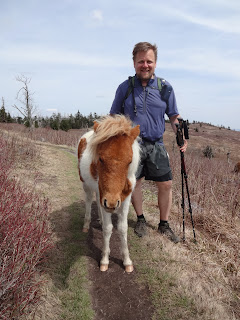
I have been taking it easy for the past two days.  I have been a bit sluggish after leaving Damascus and have not been motivated to push very far.  I did 14.7 miles yesterday and only 12.2 today.  The climb of Whitetop Mt. and then up to Mt. Rogers sapped me of quite a bit more energy then it should have.  I got into the shelter pretty early but was just not motivated to push on.  Thomas Knob shelter has a nice upper deck that is out of the weather and I think I was tempted by the promise of a night out of the wind.  The big payoff of the day was the ponies! 

The Grayson Highlands ponies are a semi-feral heard that are believed to be related to the ponies of  Assateague Island.  They are friendly and are very accustomed to people.  For a time they were totally wild but are now fenced in to the boundary of the park.  They visited the shelter that night in search of some scraps.  Seeing the ponies was on my highlight list for the hike and I am so glad that I had good weather on top of the mountain.  Owl, Zag, Magic and half a dozen new faces were all at the shelter for the night.


Tuesday, April 23, 2013

Day 47: Virginia!

Day: 47 Miles: 11.3 Trip: 468 Started: Abingdon Gap Destination: Damascus, VA


Well, this is a milestone! I'm finally in Virginia.  Virginia is a sort of Psychological hurtle for me.  Its said that about 50% of thru-hikers drop out before reaching Damascus.  If that is true then I can consider myself one of the lucky ones.  I feel that I have now learned most of what I need to know to complete my hike.  I have to come to realize that I will meet an amazing array of people on my way to Maine and I do not need to nor should I try to keep up with any one group of people.  Everybody goes at their own pace and the ebb and flow of people that come and go is a big part of the trail.  I have paired down my gear a little and have become more efficient at the daily chores of hiking the AT.  I no longer worry about re-supply or what food I should or should not take.
Me, Big Yankee, Step, Owl, Zag & Shutterbug
I eat what my body tells me it wants and the lure of towns has become a little less.  The only thing I have yet to master is getting in and out of a town with enough time to still do some decent miles.  Its still pretty tempting to linger a little longer in a town before heading back out.  I still think of home everyday and continually look forward to getting back, but the reality that this will still be my daily life for the next 4.5 months or so is less of barrier everyday.  Damascus is a wonderful trail town with three outfitters and a nice collection of hostels and B&B's.  I am going to take a zero day here and enjoy the transition to a new state.  Virginia is a big state with over 600 miles of the AT alone.  My next hurdle will be Harpers Ferry, WV. 
Taking a break at the VA border
VA is a big drop out point because people are said to get a little burnt out my the monotony of the AT in VA.  With Spring in full effect and some of the less scenic sections of the trail, hikers face less to look forward to on a daily basis.  Fortunately for me I will be taking a few days off in May and hope this breaks up the Virginia Blues as there called a little bit for me. 

Monday, April 22, 2013

Day 46

Day: 46 Miles: 15.9 Trip: 456.7 Started: Iron Mt. Shelter Destination: Abingdon Gap Shelter

Trooper, M-80 & Owl getting TM
Had a great day of hiking today under nice clear blue skies.  The ridge line has turned out to be some very nice well maintained trail.  I wish it all was this nice.  I can see now why previous hikes all claim the miles get easier after Roan Mt.  I spent the night with a bunch of people I had not seen in a while.   We all have pretty much the same plan or the next few days and together we pushed out to Abingdon Gap.  We had some nice trail magic from a local church in the form of cold sodas just before we passed through a cow pasture.  Luckily the cows just wanted to keep eating. At Abingdon I met Steps.  Steps is from the UK and we had fun teasing him about all things British.  Turns out is is both Owl and Steps birthday as well as M-80 and Troopers wedding anniversary is tomorrow.  Trooper has been Yogi'ing toilet paper the whole trail and we all decided to give them a few sheets as an anniversary gift.  Pretty much as good as it gets on trail for gifts.  


Big Yankee on the way through the pasture


Sunday, April 21, 2013

Day 45

Day: 45 Miles: 21.5 Trip: 440.8 Started: Hampton, TN Destination: Iron Mountain Shelter

Another day of good sunny weather.  I spent the entire day on a long ridge line above Watauga lake.  I hate to jinx myself, but I am starting to think that I might actually get through this trip with more good days of weather than bad.  The community of hikers on the trail is definitely something that helps remind me that the trek I am undertaking is not really a solo pursuit.  Its nice to be able to commiserate with others that have gone through the same trials and tribulations.  I stopped at Vandeventer Shelter for lunch as was pleasantly surprised to find out that Big Yankee was just ahead of me on the trail.  Ever since I got sick back in Erwin I had lost track of a little bubble of hikers that I was hiking with.  I was exited to meet back up with some faces I recognized and pushed a slightly bigger day to catch them.  At Iron Mountain shelter I caught up with Big Yankee, Zag, Owl and Shutterbug.  I had not seen Owl or Zag since Standing Bear.  Also here tonight were M-80, Trooper and their dog Willow. The trail was great today and I am truly starting to get my real stride going.  There is no such thing as flat trail, but the large roller coaster hills of Georgia and the Smoky's are a thing of the past for now.  I am only a few days away from Damascus VA!

Saturday, April 20, 2013

Day 44

Day: 44 Miles: 14.4 Trip: 419.2 Started: 404.8 Destination: Hampton TN

Had a nice sunny day coming in to Hampton.  I was not going to stop here, but I needed to re-supply and it was getting a little late in the day to push on.  The big highlight of the day was definitely Laural Falls.  The trail coming down to the falls was a little cavernous and made for a nice change from what I have been seeing for the past few days.  The trail does a steep decent down to the falls and then seems to disappear into the stream.  A small ledge right at the waters edge takes you around a rock outcropping to the rest of the trail.  It reminded me of a secret mountain pass on a small scale. In Hampton I came across one of the more peculiar combinations of business I have seen.  I had read in a shelter journal the night before that I must try burger was to be found at the Compucraft laundromat.  Kind of a strange place to find a burger!  It turns out you can do several things at this establishment.  Here you can find computer parts and repair, a laundry, a small cafe, used bicycles, a pool hall, internet cafe and they will soon also be offering hot showers.   I was able to update the blog, do my laundry and get something to eat all at the same place for about $10.  In a way its sort of a hiker paradise.


Friday, April 19, 2013

Day 43: Rain...and more rain...

Day: 43 Miles: 13.2 Trip: 404.8 Started: Elk Park Destination: 404.8

Well, not much to say about today except Rain!  It was just a light drizzle early on and I had hopes that we might avoid the deluge that was scheduled for the late afternoon but that was not to be.  By 2pm it was a full on down poor with lightning and thunder.  Dreading the thought of setting up my tent in these conditions I stopped a bit early at the Vango/Abby Memorial Hostel.  I was very glad to be out of the rain.  It seems like most hikers stayed where they were that day to avoid the rain.  Vango's is a nice place with a two story bunk house.  M-80 and Trooper came in also and took the upstairs room.  I ended up having the entire lower bunk house to myself and had the best nights sleep I have had in a long time.  I wish I had pushed more miles  but you cant beat a warm room when its raining so much.  The forecast calls for good weather for the next four or five days and I hope that true!  Only three days to VA!   No pictures today, the camera was packed away all day.

Thursday, April 18, 2013

Day 42: Goodbye NC!

Day: 42 Miles: 15.8 Trip: 391.6 Started: Roan High Knob Shelter Destination: US 19E / Mt. Harbour

What a day of contrasting weather.  I started out from the shelter under very heavy dripping fog that lasted much of the day.  The previous day I had wanted to get down to Overmountain Shelter, but did not make it due to my knee.  Overmountain is a converted barn that was built in the early 1900's. It is a favorite spot for hikers and I would have like to stay there.  Earlier in the day I cam across a trail maintenance volunteer doing a survey hike who said the recently spruced up the shelter and it could now hold up to 50 hikers.
 Unfortunately it is half a mile off the trail and I did not want to add an extra mile to my day just to take a look at it.  I did however get this picture on my way up the mountain.  The weather started to break as I went up Hump Mt. and I was able to finally get some great views again.  Even though the cloud cover had gone, it was extremely windy!  If I had to guess gusts were well over 50 mph.
 Locals I talked to later that day said that they have clocked winds over 100 mph up on the mountain.   I was blown off the trail several times and actively had to fight the wind to stay on track.  Overall though I was glad the weather was improving and the winds made things a little fun.  On the way down the Mt. I finally came to the NC/TN border.  Another state down!  For a while the trail mirrors the NC/TN border and I have been back and forth a lot over the past week or so.  Not anymore, goodbye NC!
 All and all a good day.


Wednesday, April 17, 2013

Day 41

Day: 41 Miles: 13.7 Trip: 375.8 Started: 363.4 Destination: Roan High Mt. Shelter

My second day out from recovering from the AT Plague and I am finally starting to feel better.  Unfortunately the weather is not so great.  It started out very cloudy and heavy rain clouds started to roll in.  I wanted to push a little more down the trail but my right knee was starting to get a sharp pain from time to time.   This is the first real 'pain' I have had and I did not want to push my luck.  I decided to stop a little early and stayed at Roan High Mt. Shelter.  This shelter has the distinction of being the highest shelter on the AT.
Other than that it was nothing all that special.   The night was very very windy and I was glad to be inside.  Coming off of Roan Mt. I crossed many high balds and was disappointed I did not have better weather for the views.  On the way in I met up with M-80, Trooper and their dog Willow.  I have seen them before but this was the first time I got to talk with them.


Tuesday, April 16, 2013

Day 37-39: The AT Plague!

Day: 37 Miles: Trip: 341.5 Started: Erwin TN  Destination: Bed!

For the last 70 or 80 miles I have been seeing lots of warnings around shelters of people getting a nasty stomach virus that causes people to vomit from both ends for about 24 hours.  After my long day yesterday into Erwin I was feeling pretty good and had some food and slept well.  I had planned on leaving right away the next morning, but by about 9am I was starting to feel a little queasy.  I was afraid the virus had finally caught up to me.  I had heard horror stories about people on the trail riding it out in their tents or in a shelter, but I was still in town and wanted to take the opportunity to have a pharmacy around if I needed one.  It turns out I had it pretty bad.  I did not want to stay at the hostel and be around lots of other people so I checked in to the Super8 motel and by 11am it was in full swing.  I should have been pretty hungry by then, but the mere thought of food made me want to vomit.  By 11:30 I was in bed and tried to get some sleep.  I woke up several times and managed to drink two glasses of  orange juice and some water, but the thought of  food was still pretty telling and by the time I knew it it was 3am.  The next day I was feeling a little better, and had some breakfast, but immediately had diarrhea.  I ended up staying another two days.  One to continue to recover, and another to do all the things like re-supply that I did not get done.  On the morning I left, two doctors and the county health official stopped by to take count of the number of infected at the hotel.  They were doing a study to determine the severity of the bug in the county.  Evidently it was starting to show up at many hospitals and nursing homes as well.  An article about it is available here.

Friday, April 12, 2013

Day 36: Biggest mile day so far.

Day: 36 Miles: 23.5 Trip: 341.5 Started: Sams Gap Destination: Erwin, TN

I spent the last night just past Sams Gap.  I had intended to go a little farther but a bad thunderstorm was moving in and decided it would be best to set up camp as soon as possible.  I knew I would not make it as far as the next shelter and did not want to set up in the rain.  It was a bad storm!  I had good cell service that night and Weather.com was calling for tornado warnings and severe thunderstorms.  I hunkered the outside edge of my tent as close to the ground as possible and set up a few logs around the outside to prevent splashes from getting all the way inside.  It worked pretty good and I was more or less dry in the morning.  The storm was pretty bad and woke me up a few times during the night.  The next day started out cool and very foggy, so much so that quite a bit of water was condensing and dropping from the trees all morning.  I was disappointed that Big Bald was totally fogged in and I missed out on some great views.  Later in the day the sun eventually did come back out and I decided to push all they way to Erwin to make up my lost miles from the night before.  Coming down off the ridge I had some good views of town.


Wednesday, April 10, 2013

Day 34: Forrest service ruins the day!

Day: 34 Miles: 16.8 Trip: 302.2 Started: 290.2 Destination: Flint Mountain Shelter (but did not make it)


Finally at the top of the re-route


Started the day early to get a 2000 foot climb out of the way.  The weather was great with temperatures in the 60's and sunny skies.  Got up to the top at Camp Creek bald and had a quick snack and was looking forward to an easy ridge line hike for the rest of the day.  Well, that was not how it would go at all!  After about another four miles, I encountered a group of about twelve hikers that were stopped by a Forrest Service ranger.  We were informed that they Forrest Service was conducting a controlled burn and was using the AT as part of the fire break.  Some of the hikers had been there stopped for a few hours and from what I was able to learn, the Forrest Service had no plan whatsoever to do with us all.   There were already a dozen of us backed up and I knew there wold be about twenty more by the evening.  We were stopped by a side trail that led up to an access road and it was suggested that we all just camp there for the night.  The biggest problem was that there was no water in the area and most of us had planned on getting water from one two spots in the next few miles.  After this was brought to the rangers attention, it was decided that they would shuttle us around the burn, but where we would be dropped off would be about five miles from the trail.  The location they described was an easy grade fire road that we could walk back to the AT on.  Not wanting to waste the day we all opted for the shuttle.   Forty-five minutes later we had driven all the way back down the mountain and were dropped off in a parking lot with very little instruction except that we would find the trail 'up the road' in about 5 miles.  What they did not explain to us is that the road split about six times and was at about a forty percent grade starting about one thousand feet below where we had all started that morning.  All of the sudden it turned into a sixteen mile day with a five thousand foot climb!  The delay waiting for the shuttle had already wasted about three hours and it was getting late when we started up.  I remember the ranger that stopped us had said that we pretty much followed a creek all the way up, but others from the shuttle must not have heard that because by the time I reached the top nobody else came up for more than an hour.  They must have taken different forks in the road.  Near sundown some stragglers did come up, but by that time it was getting pretty dark and  we all decided to camp at the top of the fire road. 

Smoke from the fires
The biggest appointments was that they had no plan of action for re-routing the hikers.  They could have placed signs at some of the larger gaps.  If I had known about this in the morning I would have opted to camp for the day or stay another night at the hostel from the day before.  I understand they have very few windows of opportunity to conduct these burns, but putting up a few simple signs in the morning would have helped quite a bit, especially with the number of hikers on the AT this time of year.  One hightlight of the day was getting to see one of the first signs of spring.  It had to come sometime, I just wish it had happened while I was in the Smoky's.

First signs of Spring

Tuesday, April 9, 2013

Day 33

Day: 33 Miles: 11.1 Trip: 290.2 Started: 279.1 Destination: Hemlock Hollow Hostel


First hot day.  Today was one of the first days that I actually felt hot.  I did not think it was affecting me all that much but by the early afternoon I was getting really tired from the sun and heat.  The trees have not yet bloomed so for now I am in the sun all the time.  I was not planning on stopping so early but I thought I would check out a newer hostel on the trail.   I slightly wish I had not.  I have mixed opinions about Hemlock Hollow.  The location is comprised up a few cabins, bunk house and an office that has some resupply and a small cafe.  My biggest complaint is about the management.  While they are nice enough people, they are not focused on running their business and are vague on prices and hidden fees.  If you choose to stay here in the future make sure you know for sure how much things cost.  I wish them luck with the business, but they need to focus more on proper management and staffing.  One of the highlights of the day was the view from the Camp Creek Bald Lookout Tower.

Monday, April 8, 2013

Day 32

Day: 32 Miles: 5.2 Trip: 279.1 Started: Hot Springs, NC Destination: ??

Hot Springs on the way out


I took a long time getting ready to get out of town and made the mistake of not checking the post office hours.  Welcome to small town America! The post office was closed from 11 am to 1:30 pm and I had to wait for it to re-open in order to send some gear home.  In Hot Springs I decided to change out my alcohol stove for a canister stove.  My alcohol was working just fine, but I was getting tired of the longer boil times. I think this might be due to my stand/wind shield design not letting enough air flow around my pot.  I did not have the tools to make a new one and decided to just go with the canister stove for now.  While I waited I used to library computers to catch up on a few things and before I knew it it was almost 2pm.  I did not leave town until 3pm and instead of staying in town again I opted to get up to the ridge and do a short mile day.  I ended up staying in the fields above a small damn at about mile 280.


First signs of Spring

Saturday, April 6, 2013

Day 30

Day: 30 Miles: 19.8 Trip: 273.9 Started: Max Patch Destination: Hot Springs, NC

Not much to say about today except it was another great day of hiking. I had good weather again today and was able to do my first (almost) 20 mile day.  I was glad to be getting into town and was looking forward to experiencing Hot Springs, as I have heard so much about it.  I will most likely do a zero in town to catch up with a few people that are a little behind me.  Nothing looks quite as good as a town from a high ridge when you have a hunger for town food on your mind.

Friday, April 5, 2013

Day 29: Happy Birthday Mary!

Day: 29 Miles: 14.3 Trip: 254.1 Started: Standing Bear Hostel Destination: Max Patch

What a day of contrasts today was.  The morning started out cold and rainy.  The previous night there had where freezing temperatures and the forest was coated in a think blanket of ice.  I encountered many downed trees from the ice storm.  As the morning went on, the ice was coming down in pretty large chunks making just walking down the trail a mind game as I hoped the chunks would miss my head.  I had some close calls with some, but managed to get through most of it without getting hit too bad.  By mid afternoon the sun had started to come back out and the day was looking up.   One of the views that I was looking forward to most was the one from Max Patch bald.  I was lucky to get up to Max Patch under beautiful clear skies as had a great view of the surrounding mountains.  I was really happy to get these views.   It was late enough in the day that I decided to stay with my friends up on Max Patch and was rewarded with a beautiful sunset.  One of the better days so far.  Today was Mary's birthday and I thought about how nice it would be if she was here to see the sunset.  Perhaps we will come back someday for a section hike.  Happy Birthday Mary!


Thursday, April 4, 2013

Day 28: Standing Bear

Day: 28 Miles: 3.6 Trip: 240.8 Started: Davenport Gap Destination: Standing Bear Hostel

Standing Bear hostel is one of the places I had heard so much about when I first started researching the trail.  I only did a short 4 mile day so I could stay here and resupply.  Its a great place with a very laid back attitude and a friendly staff.  Its not the Ritz, but the rates are fair and they have everything you need. It was worth the short stay.  Peaches the cat decided to make my bunk her bed for the night, I did not mind the extra heat.


Wednesday, April 3, 2013

Day 27

Day: 27 Miles: 14.8 Trip: 237.2 Started: Tri-Corner Knob Destination: Davenport Gap Shelter

Finally a great day in the Smoky's even though it was near the end.  The sun was out all day and after about five miles I had descended below the snow level and once again entered clear trail.  Sometimes its the little things that matter like being able to walk ten steps in a row without concentrating on every single step. Even though the trail was getting down below the ridge line it was good to be out of the snow.  I'm glad to be out of the higher mountains for now, but would love to come back here sometime and experience the ridge lines without all the ice and snow.

Tuesday, April 2, 2013

Day 26

Day: 26 Miles: 15.6 Trip: 222.4 Started: Newfound Gap, TN Destination: Tri-Corner Knob Shelter

I waited out some of the bad weather running through the Smoky's in Gatlingburg, TN.  Gatlingburg is a study in contrasts from life on the trail.  Coming out of the national park you hit a traffic light and immediately enter a tourist boon town.  The city itself reminds me of a busy New Jersey shore town boardwalk.  Games of chance, dozens and dozens of T-shirt shops, miniature golf and funnel cake stands.


The rain over the past two days and the warming temperatures helped a lot to knock down the snow and slush, but the trail was still very slick with compacted snow and frozen slush.  Even still, it was easier to walk on and I was able to get in almost 16 miles.  This was one of the better days I have had in the Smoky's so far as the sun was out most of the day.